- Introduction
- Background & Context
- Key Concepts Explained
- Key Issues / Developments in the News
- Significance of the Issue
- Challenges / Concerns / Criticisms
- Government Initiatives / Policies / Committees
- Way Forward (UPSC-Style)
- Linkage with UPSC Syllabus
- Prelims Focus – Key Facts & Keywords
- Practice Questions
- Conclusion
Introduction
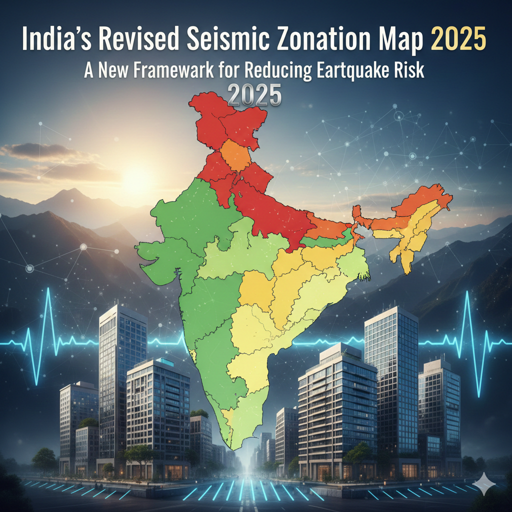
India has unveiled an updated seismic zonation map as part of the revised Earthquake Design Code, 2025 (IS 1893) notified by the Bureau of Indian Standards (BIS). This marks the most significant overhaul of India’s seismic hazard assessment in decades.
The revised map places 61% of India’s landmass, accommodating nearly 75% of the population, under moderate-to-high seismic hazard zones. A key highlight is the creation of a new highest-risk category — Zone VI, under which the entire Himalayan belt has been classified.
This development is crucial for UPSC aspirants as it directly links geography, disaster management, urban planning, governance, and sustainable development, making it relevant for both Prelims and Mains.
Background & Context
Historical Background
India’s earlier seismic zonation maps divided the country into four zones (II to V), based largely on historical earthquake intensity and past records. Zone V represented the highest seismic risk.
However, rapid urbanisation, improved geological data, and advancements in hazard modelling made the older framework inadequate to address contemporary risk realities.
Previous Developments
- Seismic zonation maps revised periodically, but without fundamental methodological change
- Focus remained primarily on structural safety, ignoring non-structural vulnerabilities
- Himalayan region divided across Zones IV and V despite shared tectonic characteristics
Indian Context
India lies at the collision boundary of the Indian Plate and Eurasian Plate, making large parts of the country, especially the Himalayas, tectonically active and earthquake-prone.
Key Concepts Explained
Seismic Zonation Map
A scientific classification of regions based on the probability and intensity of earthquake-induced ground shaking, used to guide construction and urban planning.
Probabilistic Seismic Hazard Assessment (PSHA)
A modern method that:
- Considers likelihood of earthquakes
- Accounts for intensity of ground shaking
- Integrates multiple potential earthquake sources
Unlike deterministic approaches, PSHA provides a more realistic risk profile.
Structural Elements (SEs)
Load-bearing components of buildings such as:
- Beams
- Columns
- Walls
- Foundations
Architectural Elements and Utilities (AEUs)
Non-structural components supported by SEs, such as:
- Glass panels
- Ceilings
- Lifts
- HVAC systems
Damage to AEUs can cause casualties even if buildings remain standing.
Exposure Window
A concept that combines:
- Population density
- Infrastructure concentration
- Urban growth patterns
- Socio-economic vulnerability
to assess human and economic impact, not just geological risk.
Key Issues / Developments in the News
1. Introduction of Zone VI
- New highest seismic hazard category
- Entire Himalayan belt (Jammu & Kashmir to Arunachal Pradesh) placed under Zone VI
- Recognises uniform tectonic vulnerability of the Himalayas
2. Expansion of High-Risk Areas
- Earthquake-prone landmass increased from 59% to 61%
- Cities on zone boundaries classified under higher-risk zone by default
3. Methodological Shift
- Adoption of PSHA and Probabilistic Exposure and Multi-Hazard Assessment (PEMA)
- Focus on both physical hazard and human exposure
4. Revised Design Standards
- Earthquake Design Code, 2025 introduces standards for:
- Structural safety
- Protection of AEUs
- Mandatory compliance urged for all new infrastructure
Significance of the Issue
Political
- Strengthens disaster risk governance
- Improves Centre–State coordination in Himalayan states
Economic
- Reduces long-term economic losses from infrastructure collapse
- Protects supply chains, commercial hubs, and industrial assets
Social
- Enhances public safety in densely populated regions
- Protects hospitals, schools, and essential services
Environmental
- Promotes sustainable and resilient urban development
- Reduces secondary disasters like landslides and fires
Ethical / Governance
- Shifts focus from reactive relief to preventive resilience
- Aligns governance with citizen safety and intergenerational equity
Challenges / Concerns / Criticisms
Implementation Issues
- High cost of retrofitting old buildings
- Shortage of trained structural engineers
Administrative Challenges
- Weak enforcement of building codes at local level
- Urban local bodies lack technical capacity
Federal Concerns
- States must revise building bylaws and urban plans
- Uneven preparedness among Himalayan states
Social Challenges
- Informal settlements and unregulated construction remain vulnerable
Government Initiatives / Policies / Committees
- Earthquake Design Code, 2025 (IS 1893)
- National Disaster Management Authority (NDMA) guidelines
- Prime Minister’s 10-Point Agenda for Disaster Risk Reduction
- Focus on technology
- Risk-informed infrastructure
- Capacity building
- Alignment with:
- SDG 9 – Resilient infrastructure
- SDG 11 – Safe and sustainable cities
Way Forward (UPSC-Style)
- Institutional reforms to strengthen enforcement of building codes
- Capacity building of urban local bodies and engineers
- Mandatory seismic audits and retrofitting of critical infrastructure
- Technology integration through early warning systems and GIS-based planning
- Promotion of traditional earthquake-resilient construction practices
- Strengthening cooperative federalism for disaster preparedness
- Focus on inclusive and risk-informed urban development
Linkage with UPSC Syllabus
Prelims
- Geography: Earthquakes, tectonic plates
- Disaster Management
- Environment & Ecology
Mains
- GS I: Physical geography – earthquakes and tectonics
- GS II: Governance, disaster management institutions
- GS III: Disaster management, infrastructure, urban planning
- Essay: Urban resilience, disasters and development
Prelims Focus – Key Facts & Keywords
- Seismic Zones: II, III, IV, V, VI (new)
- PSHA, PEMA, Exposure Window
- Bureau of Indian Standards (BIS)
- IS 1893: Earthquake Design Code, 2025
- Himalayan Faults: MCT, MBT, MFT/HFF
- Major Earthquakes: 1897 Shillong, 1905 Kangra, 1934 Bihar–Nepal, 1950 Assam–Tibet, 2001 Bhuj
Practice Questions
Mains
10 Marks:
Explain why the Himalayan region is highly vulnerable to earthquakes. How does the revised seismic zonation map address this vulnerability?
15 Marks:
Evaluate the implications of India’s revised seismic zonation map on urban planning and disaster risk governance in Himalayan states.
Prelims MCQs
- Which institution released the revised Earthquake Design Code, 2025?
- The PSHA method considers which of the following?
- Zone VI in the revised seismic map primarily covers which region?
- Which fault is the southernmost Himalayan fault?
- Which SDGs are directly linked to resilient infrastructure and cities?
- The concept of “exposure window” relates to which aspect of disaster management?
Answers:
- BIS
- Likelihood and intensity of ground shaking
- Himalayan belt
- Himalayan Frontal Fault (HFF)
- SDG 9 and SDG 11
- Human and economic vulnerability
Conclusion
India’s revised seismic zonation map represents a decisive shift from reactive disaster response to risk-informed planning and resilience building. By integrating advanced hazard assessment methods and recognising human exposure, the new framework strengthens urban safety and governance. Effective implementation, cooperative federalism, and capacity building will be critical to translating this scientific advancement into long-term disaster resilience.